
How to read a nautical navigation chart
Andy Phenna, Head of Offshore Training, shares his top tips on how to use nautical charts
Whether you’re going on an offshore adventure or doing a course in nautical navigation, it’s useful to have a basic understanding of how to use a nautical chart. These tips will help you find your way.
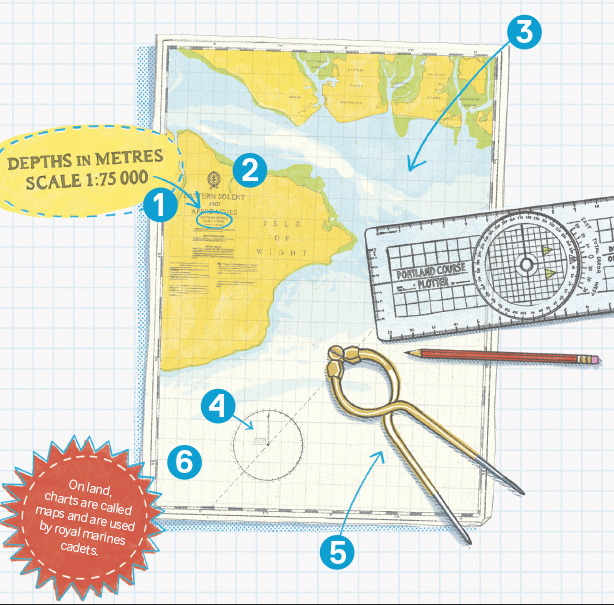
1. Depth
Check the depth measurements (soundings) on your chart. Some charts show depths in fathoms and feet, but metres are more use to us in the UK. The depth measurement is usually calculated for the lowest possible level of tide, so you will normally have more actual water underneath you than it says on the chart.
2. Scale
Know the scale of the chart you’re using. It’s no use trying to enter Aberdeen harbour using a map showing the whole of the UK. Large scale charts show rivers and harbours; small scale charts are used to plan passage from port to port.
3. Colours
Use the colours to guide you. At Sea Cadets we say, “Sail on the blue or white and stay off the yellow.” The green bits are more tricky – sometimes they’re above water and sometimes they’re underwater.
4. Plotting
To plot a course, use the compass rose drawn on the chart, but remember the difference between a ‘true course’ and a ‘magnetic course’ as a result of the Earth’s magnetic fields. Use a plotter to line up along your route and then read off the course.
5. Distance
To measure distance use a pair of dividers (like a drawing compass but with two points). Use the scale on the left or right side to convert your measurement to nautical miles (1 minute of latitude = 1 nautical mile).
6. Position
To plot your position you need to know how far north or south of the equator you are and how far east or west of the Greenwich Meridian you are. We plot the latitude (north/south) first using the scale on the left or right of the chart, then the longitude (east/west) using the scale on the top or bottom.
Illustration by Carys Tait www.carys-ink.com
More Advice

Volunteer spotlight: Communications Team
MSSC’s Communications Team is proud to help our volunteers be the best possible ambassadors for our organisation – bringing their unit’s stories to life and enhancing their profile and reputation

So you want to be an…executive chef at a top restaurant?
Former sea cadet Daniel Heffy has worked in several Michelin-starred restaurants and was selected to represent the North West on the BBC’s ‘Great British Menu’. Now Executive Chef at NORD in Liverpool, he has a reputation for producing exceptional cuisine from local and seasonal ingredients
